Physical geography and geology of Spain
- The name Iberia was first used in the 6th century BC by a Greek author in reference to the Iberians, or the people who lived along the Iberus river. Today Spanish-speakers call it the Ebro and Catalan-speakers the Ebre. Ibai in Basque is river.
- Strabo the first-century Roman geographer described the Peninsula as an ox-hide. " Iberia is like an ox-hide extending in length from west to east, its fore-parts toward the east, and in breadth from north to south". Some translations, perhaps looking for the easy cliché give it as a bull's hide.
- Spain itself takes its name from the Latin Hispania. The word is probably Phoenician in origin, derived from shepham probably meaning 'coast or island of rabbits'. The rabbit, at the time, was endemic and virtually restricted to the Peninsula. The oldest existing fossil of a rabbit is a specimen from 2.5 million years ago found in Granada. In fact, the rabbit did not really expand from Iberia until the Phoenicians, began to export it around the Mediterranean.
- Spain is separated from Punta de Ceres in Africa by 13.4 km at its narrowest point in the Straights of Gibraltar (Estrecho de Gibraltar, or just El Estrecho) at Tarifa, the southernmost town in Europe (Latitude 36º 1º N). Tarifa takes its name from the Berber leader Tarik who carried out a recognisance mission into Andalusia , one year before the 711 Islamic invasion. Nearby Gibraltar takes its name from Jebel Tariq (Tariq's mountain- in Arabic ??? ????). In the Ancient World, the rock was one of the two Pillars of Hercules , along with Jebel Musa (Monte Hacho in Spanish) on the other side of the Straights. The Phonecians also knew of Gibraltar and called it Calpe.
- Richard Ford, the 19th century traveller and first British hispanophile, jokingly said in 'Gatherings from Spain' that the country is just one big mountain. 24% is above 1000 m and 76% between 500 and 1000 m. Spain has an average altitude of 660 metres. In Europe only Switzerland is higher (by a long way - average altitude of 1,300 metres).
So it should come as no surprise that Castilian is so rich in words for mountains, hills, cliffs and plateaus. Here's a by no means exhaustive list.
- Of the 505,988 km2 of Spain , 57,615 km2 are below 200m, 156,370 km2 are between 201 and 600m, 198,650 km2 are between 601 and 1,000m, 88,766 km2 are between 1,000 and 2000m; and 4,587 km2 higher.
- Only 12% of mainland Spain lies at a gradient of less than 1 in 20 (5%).
Also on Iberianature:
|
- See also Mountains in Spain
- Spain 's total official surface area is 505,955 km2. It occupies around 80% of the Iberian Peninsula -493,514 km2 of 582,881 km2. The Balearic Islands are 4,992 km2, while the Canary Islands are 7,447 km2. There are also a few smaller islands and territories including the two Spanish cities in North Africa : Ceuta , with 20 km2 and Melilla with 12 km2.
- Land boundaries: 1,917.8 km ( border countries: Andorra 63.7 km, France 623 km, Gibraltar 1.2 km, Portugal 1,214 km, Morocco (Ceuta) 6.3 km, Morocco (Melilla) 9.6 km).
- Spain has three small possessions off the Moroccan coast - Islas Chafarinas, Peñon de Alhucemas, and Peñon de Velez de la Gomera.
- 24% of Spain is above 1000 m and 76% between 500 and 1000 m. Spain has an average altitude of 660 metres. Only Switzerland, with an average altitude of 1,300 metres, is higher.
- Spain 's mainland coastline is 5,755 km long. The Balearic coast is 1,186 long.
- Of the 179 habitats described by the EU, 65% are present in Spain.
- Spain takes up 85% of the Iberian Peninsula
- The classic Castilian Meseta occupies some 40% of the country - 210,000 km2, and has an average altitude of 650 m. Salvador de Madariaga described this vast plateau as 'the inner citadel of the fortress which is Spain '. It is split in two by the Sistema Central (Guadarrama and Gredos ranges), creating Old Castile to the north and New Castile to the south (nowadays termed Castilla y León and Castilla La Mancha). The northern 'submeseta' is the higher of the two at between 850-800m, while the southern 'submeseta lies between 500 and 700m high.
- Of the 505,988 km2 of Spain , 57,615 km2 are below 200m, 156,370 km2 are between 201 and 600m, 198,650 km2 are between 601 and 1,000m, 88,766 km2 are between 1,000 and 2000m; and 4,587 km2 higher.
- Only 12% of mainland Spain lies at a gradient of less than 1 in 20 (5%).
- Madrid is the highest capital in Europe (if one discounts Andorra la Vella - 1,050 m and Vaduz - 708m ) A plaque in Puerta del Sol, the officially "the centre of Spain , indicates that the square stands at 650.7m.
Geology of Spain
Geologically, Spain can be divided in terms of bedrock.
- A siliceous Spain seated on hard and therefore durable crystalline rocks (granites, schist and gneiss) forming acid soils and poor in carbonates - the North and the West of the Peninsula;
- A limestone Spain based on sedimentary rocks - the heavily weathered Mesesta.
Spain contains some of the best exposed outcrop geology in Europe. Wikipedia has this excellent introduction to
the Geology of the Iberian Peninsula
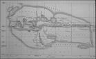
"The Iberian Peninsula contains rocks from every age from Ediacaran to Recent, and almost every kind of rock is represented. The core of the Iberian Peninsula consists of an Hercynian cratonic block known as the Iberian Massif. In the northeast this is limited by the Pyrenean Fold Belt, and in the southeast it is limited by the Betic Foldchain. These two fold chains are part of the Alpine Belt. The western peninsula is delimited by the continental boundary formed by the magma poor opening of the Atlantic ocean. The Hercynian Foldbelt is mostly buried by Mesozoic and Tertiary cover rocks on the east side, but nether the less outcrops through the Iberian Chain and the Catalonian Coastal Ranges. Read Geology of the Iberian Peninsula (wikipedia)  Click for full image Click for full image
- Latest news and articles on Spanish geology here on the blog
- The largest cave chamber in Europe is the Torca del Carlista in the Basque Country. It measures some 520 metres by 245m. It is the fourth (not the second as some sources claim!) largest cave chamber in the world. Legend has it that a Carlist follower threw himself to his death here rather than be taken alive. Caves in Spain
- The worst earthquakes in the Pyrenees in the historical record were in the Olot region in 1427 and 1428 with intensities of greater than X*. Olot was totally destroyed, with extensive damage across Gerona. In excess of 800 people were killed. The single most deadly earthquake in modern Spanish history occurred in Arenas de Rey in Granada in 1884. Almost 800 people were killed . See Earthquakes in Spain
- 28/07/2006 New study of Galician rocks doubles age of Iberian Peninsula to 1160my (El Mundo)
|
Spain soil map
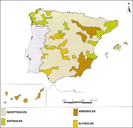
Source: hispagua
iberia geology, iberian geology, geology of Iberia, Geology of Andalusia, Geology of Catalonia, Geology of Aragon, Geology of Asturias, Geology of Balears
Geology of Basque Country and Navarra, Geology of Canarias, Geology of Cantabria, Geology of Castilla y León, Geology of Castilla-La Mancha, Geology of Extremadura, Geology of Galicia, Geology of Madrid, Geology of Murcia, Geology of Navarra, Geology of Valencia, Geology of Andalucia, Geology of Catalunya, Geology of Iberian Peninsula
|
News on geology in Spain
Latest news and articles on Spanish geology here on the blog
|
|